Peutinger Map
Peutinger map or Tabula Peutingeriana: medieval copy of an ancient Roman map, an invaluably important source for the study of ancient topography.
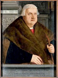
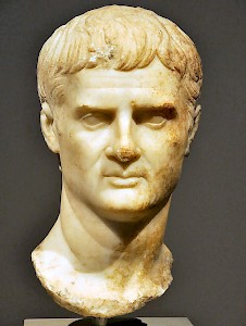
Konrad Peutinger (1465-1547) was a Renaissance man in every sense of the word. Born as a patrician of the German city of Augsburg, he took degrees in classics and law at the famous universities of Bologna and Padua, served as Stadtschreiber (town clerk) in his home town and advisor to the emperor of Austria, was something of an archaeologist, collected coins, ancient manuscripts and old books, owned the largest private library north of the Alps, published the first printed collection of Roman inscriptions, and exchanged letters with the greatest scholar of his age, Desiderius Erasmus of Rotterdam. He was married to Margareta Welser, a member of one of the wealthiest families of Germany and a scholar in her own right.
In 1508, his friend Konrad Bickel or Celtes (1549-1508), the librarian of the emperor Maximilian of Austria, died, and Peutinger inherited an old map, which Bickel claimed to have found "somewhere in a library" in 1494. He had been a notorious collector and there is some doubt about the lawfulness of his acquisition. However this may be, the map now belonged to Peutinger, and has ever since been called Tabula Peutingeriana or Peutinger map. He recognized the map as a medieval copy of a Roman map, but was unable to prepare its publication.
This was left to Marcus Welser, a relative of Peutinger's wife and mayor of Augsburg. In 1591, the Fragmenta tabulae antiquae were published in Antwerp, at the famous publishing house of Johannes Moretus. The first modern edition is that of Konrad Miller of 1887, which was reprinted in 1976 and still is the best version we have. E. Weber, the editor of the 1976 facsimile, however, warns that there are several minor errors in the Miller edition.
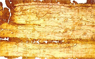
The most characteristic aspect of the map is its odd size. The eleven sheets of parchment have a total length of 680 cm and are just over 33 cm high. Although the map shows towns, seas, rivers, forests, mountain ranges, and 200,000 kilometer of roads, it is too compressed to be a real rendering of the landscape. Its creator did not attempt to show places and distances at the same scale, nor is the north always at the top of the map. It is better compared to the maps of the subways in modern cities, showing how one has to travel and mentioning the distance between the stops, but without pretension to show the surface of the earth. The first sheet, for example, shows the eastern part of Britain, Holland, Belgium, a part of France, and the west of Morocco. One would have expected the countries of the Iberian peninsula, but they are missing. This part of the Roman world must have belonged to the twelfth sheet (now lost), which offered Spain, Portugal, and the western part of Britain.
The manuscript can be dated to the twelfth or thirteenth century, but it is clear that it is a copy of a much older original. Medieval maps had a different shape. The original was drawn after 328 CE, because the map mentions Constantinople, which was founded in that year. Yet, it is clear that this late ancient map was not up to date, because it also shows Pompeii, which was not rebuilt after it was destroyed by the Vesuvius in 79 CE. The cartographer also shows the towns of Germania Inferior, which were abandoned at the beginning of the fifth century. We can therefore accept as a fact that the cartographer lived in the fourth century. He has been identified with a man named Castorius, but this identification has been challenged.
The unknown cartographer used older sources, which date back to the first century. Perhaps we can be a bit more precise. The map mentions the kingdom of a man named Cottius in the Alps, but this was no longer an independent state after 63 CE. The oldest source, therefore, belongs to the first half of the first century.
It is probably identical to the world map that was prepared by Marcus Vipsanius Agrippa (64-12 BCE), a personal friend of the emperor Augustus. After his death, his map was carved into marble and set up in the Porticus Vipsania, not far from the Altar of Peace in Rome, along the Via Flaminia. This world map, which is also known from the Natural history of Pliny the Elder (23-79 CE), was updated several times - for example, to document the Roman conquest of Britain, Dacia, and Mesopotamia. The fourth-century cartographer was the last to update an older map, but did not know every change that had taken place in the three-and-a-half or so centuries between Agrippa and his own age.
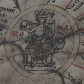
The result of his activity, however, is impressive. The map shows the entire Roman empire, the Near East, and India as far as the Ganges and Sri Lanka. Even China is mentioned. No less than 555 cities and 3,500 other place names are shown, often illustrated with small pictures. A town usually consists of two houses, and great cities (Rome, Constantinople, Antioch) receive a medallion. Lighthouses and sanctuaries (e.g., Saint Peter's church near Rome) are also indicated, although not all of them. The distances mentioned on the Peutinger map - usually in miles, but sometimes in Gallic leugae or Persian parasangae - are more or less correct.
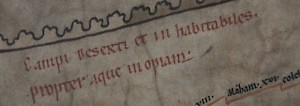
The fourth-century cartographer has also added some comments on landscapes known from the Bible. For example, in the Sinai desert, we read that Moses and the children of Israel wandered here for forty years.
When the cartographer shows the legendary edges of the earth, he uses authors like the elder Pliny, Herodotus of Halicarnassus, or the historians describing the Persian and Indian expeditions of Alexander the Great. In India, the map shows the places where scorpions and elephants are born, and also indicates the site where Alexander decided to return.
The importance of the Peutinger map cannot be overestimated, because it has offered classicists and archaeologists an easy access to ancient geography. Although it is not a real map, it offers distances, which has made it relatively easy to identify ancient sites, or to interpret the archaeological remains.
The eleven sheets are now in the Österreichische Nationalbibliothek in Vienna. The full map is shown here.
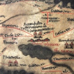 Peutinger Map, Judaea |
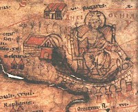
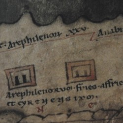 Arae Philaenorum on the Peutinger Map |
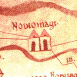 Peutinger map: Noviomagus, Arenacum, Ceuclum |
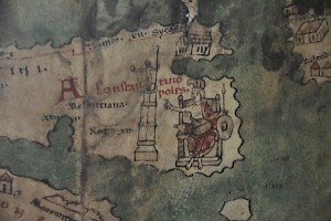
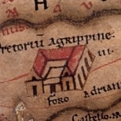 Praetorium Agrippinae on the Peutinger Map |
Literature
- E. Weber, Tabula Peutingeriana. Codex Vindebonensis 324, 1976 Graz