Levefanum (Arnhem-Meinerswijk)
Q1309559Arnhem-Meinerswijk: site of a Roman limes fort, almost certainly identical to Levefanum.
Meinerswijk
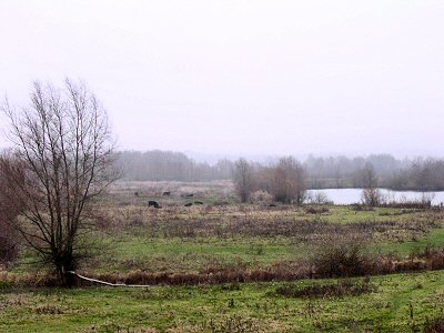
Meinerswijk, the southern part of the Dutch city of Arnhem, was already suspected to be the place of an ancient settlement, because there was a concentration of phosphate on the site. Because this is often an indication for the presence of an ancient settlement, the discovery in 1979 was not entirely unexpected. Yet, it caused some sensation, because until then, no forts were known between Vechten in the west and Alt-Kalkar in the east. A gap in our knowledge of the Roman limes (frontier) had been filled.
A tiny part of the fort was excavated. Several types of early pottery suggest that the first building phase dated to the beginning of the first century, possibly when the Roman general Germanicus attacked the Germanic tribes (14-16), or a bit earlier (immediately after the battle in the Teutoburg Forest in 9?).
Initially, it was believed that this was the "fort of Hercules" (Castra Herculis), mentioned on the Peutinger map and by the Roman author Ammianus Marcellinus as a fort rebuilt in 359 CE.note This identification was problematic, however. In the first place, Meinerswijk offered hardly any finds from the fourth century; in the second place, even if Meinerswijk and Castra Herculis were identical, we needed to assume that the fort had changed its name, because "castra" was not a common name before the fourth century. The age of the finds simply did not match the age of the name.
It has also been argued that Meinerswijk was intended as a Roman bulwark at the entrance of the Canal of Drusus, which connected the rivers Rhine and IJssel and was dug by Roman soldiers at the end of the first century BCE. This has been refuted, since it has turned out that the canal, which is known from literary sources only, is not identical to the canal between Rhine and IJssel, which was dug in the Middle Ages.
Occupation levels
The second level of occupation can be dated to the reigns of the emperors Claudius and Nero. Probably, this fort was built by Corbulo, a Roman commander who was active in Germania Inferior in 47 and used the Canal of Drusus to attack the Frisians and Chauci in the north. The presence of soldiers of the Fifth legion Alaudae is certain, although the fort must usually have been occupied by auxiliaries. Large quantities of burnt wood prove that Meinerswijk was razed to the ground during the Batavian revolt.
It was rebuilt. Parts of a ditch and a road have been identified, and it is clear that ceramics were imported from nearby Nijmegen, where the Tenth legion Gemina owned a pottery.
At an unknown moment, perhaps when the emperor Hadrian visited Germania Inferior and ordered several construction activities (121), Castra Herculis was again rebuilt. Phase four lasted until the early third century, when the military settlement was replaced by a fort that was at least partially made of stone.
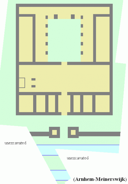
A roof tile mentioning the First legion Minervia and its surname Antoniniana can be dated after 211, because only two emperors can have awarded this title to this unit: Caracalla (211-217) and Heliogabalus (218-222). The second candidate is more plausible, because the legion's surname was immediately dropped when this tyrannical emperor was assassinated. This would not have been necessary when the title had been awarded by Caracalla, who was appreciated by the legions. The fifth level can therefore be dated fairly precisely to the years 218-222. A large stone building inscription (picture) also mentioning I Minervia can therefore be dated to a slightly earlier or slightly later time, when the unit used its title Pia Fidelis.
Like almost all other forts along the Lower Rhine, Castra Herculis was probably left after the crisis of 274, when the emperor Aurelian conquered the Gallic Empire and destroyed the empire's defenses.
Frankish pottery from the fifth century suggests that the site was still occupied. At that time, it was called Meginhardiswich, "castle of Meginhard".
Levefanum
Meinerswijk is situated between Maurik and Herwen, ancient Mannaricum and Carvium, and it is likely that Meinerswijk's original name was Levefanum, which is known from the Peutinger Map. This suggests that the site was close to a sanctuary (fanum). Assuming that the map contains a spelling error, the sanctuary may have been dedicated to the Batavian goddess Haeva (Haevae Fanum).
Literature
- B. Makaske, G.J. Maas & D.G. van Smeerdijk, "The age and origin of the Gelderse IJssel", in Netherlands Journal of Geosciences 87/4 (2008)
- J.G.M. Verhagen, "De Gelderse limes herzien. Een nieuwe identificatie van Romeinse plaatsnamen in Gelderland" (in: Archeobrief 17/3 (2013) 29-37)