Laurum (Woerden)
Q2089258Laurum or Laurium: name of a Roman limes fort along the Lowe Rhine, modern Woerden in the Netherlands.
Archaeologists and historians have long suspected that there was a Roman fort somewhere in the center of the modern Dutch city of Woerden, because a castellum named Laurium or Laurum is shown on the Peutinger map. The city center, situated on a (very low) hill and dominated by a church that dates back to the Carolingian age, is one of the few possible locations. From this site, the Romans guarded a small river, the Grecht, flowing south from the peat country on the north bank of the Rhine.
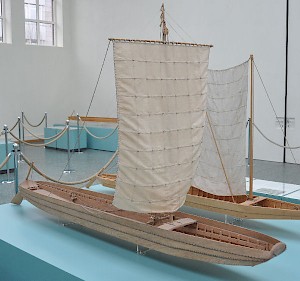
The river port of this fort and a ship were discovered in the 1980s. Another ship, discovered in 1978 and known as Woerden 1, carried a load of grain and palaeobotanists were able to identify the weeds. More precisely, they were able to establish that these weeds (and therefore the cereals) came from the fertile loess of the valley of the Meuse, probably from Tongeren. The wood was cut in 169.
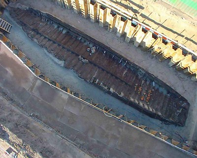
Parts of a galley (comparable to the ship known as Oberstimm 2) and a complete, 30 meter long freighter were found in 2003. This ship, known as Woerden 7, was made from wood that was for a large part cut in 163 somewhere in the Netherlands, and had - remarkably - been caulked with reed mace instead of moss. It is the twin of a barge found at Zwammerdam, 15 kilometers downstream. A report from the sixteenth century may refer to a Roman barge as well; together with two canoes, we reach the grand total of no less than seven Roman ships at Woerden.
|
|
1576 | Holle Bolwerk | Freighter? |
|
|
1978 | Groenendaal Library | Freighter |
|
|
1988 | Gas plant Oranjestraat | Freighter |
|
|
1988 | Gas plant Oranjestraat | Canoe |
|
|
1998 | Gas plant Oranjestraat | Canoe |
|
|
2003 | Nieuwe Markt | Freighter |
|
|
2003 | Nieuwe Markt | Galley |
The exact site of the fort was identified in 1999-2000 when the traces of ditches that once surrounded the southeastern and southwestern side of the fort were finally found. The inside of the old castle has not yet been investigated (except for one very small excavation). The most recent investigations focus on the area between the fort and the ancient course of the river Rhine.
At the moment, there is evidence for four successive building phases; coins prove a fifth phase. Numismatic evidence suggests that the first Roman settlement at Woerden dates back to the reign of the emperor Caligula, who visited the area in 40 and whose building activities are also known from Vechten and Valkenburg. In this building phase, fort Woerden had a north-south orientation that was not repeated when the settlement was rebuilt in c.47, when the Roman general Gnaeus Domitius Corbulo reorganized the Rhine frontier. (A slightly earlier date cannot be excluded.) This second fort, from the reign of Claudius, faced the southwest and southeast. It was destroyed by the Cananefates or Batavians, who revolted against the Romans in the summer of 69 and destroyed two legions.
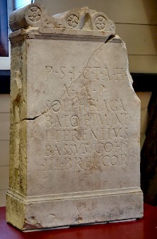
After 70, during the reign of Vespasian, the third fort was built. The village next to it is better known; only one very small excavation has taken place inside its walls; the remains of a house have been found, but they cannot be identified with any certainty (barracks or officer's mansion?). Roof tiles prove that the unit that occupied Woerden in the second century was the Cohors XV Voluntariorum civium Romanorum, the fifteenth regiment of volunteers, recruited from Roman citizens. One remarkable aspect of this fort is the heavy wooden sheet piling of the ditch. This building technique is without parallel in the ancient world.
All these forts were made of wood. In the fourth building phase, the castle was rebuilt from natural stone and brick - at least, that is what is usually assumed, because this is the end of the development of all comparable forts (e.g., nearby Utrecht). Direct evidence, however, is absent and we cannot reconstruct the map of Woerden IV. On the other hand, the presence of large amounts of tuff and other natural stone suggests that after the mid-second century, Woerden was reconstructed from stone too. Roof tiles with the stamps of the Thirtieth legion Ulpia Victrix, which was stationed at Xanten, suggest the same, because they were produced between 140 and 180 only.
By then, the fort was occupied by the Cohors III Breucorum. (The Breuci lived on the river Sava in what is now Croatia.) The soldiers imported their food from the valley of the Meuse, as can be deduced from an analysis of the cargo of the Woerden 1.
Like all forts along the Lower Rhine, Woerden must have been evacuated in c.274, when the emperor Aurelian reintegrated the independent Gallic Empire in the Roman empire. Many troops were killed in battle or transferred to Italy, and the Rhine frontier collapsed.
After a quarter of a century, the Romans returned to the Lower Rhine. For Woerden, this is proved by coins from the reigns of the emperors Constantine I the Great (307-337), Constantinus II (337-340), Constans (337-350), Valentinian I (364-375), and Theodosius I (378-395). Direct archaeological evidence is absent.
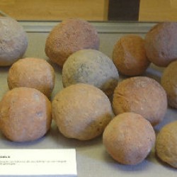 Woerden, Catapult stones |
 Woerden, Samian ware, inscription "Lucani" |
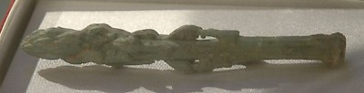
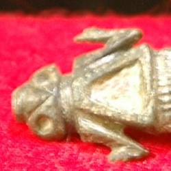 Woerden, Metal frog |
 Woerden, Roof tile Coh(ortis) XV vol(untariorum) |
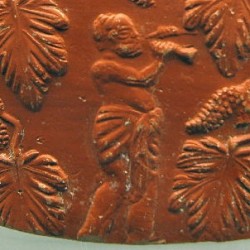 Woerden, Sherd of Samian ware with a flutist |
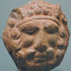 Woerden, Mask of Jupiter-Ammon |
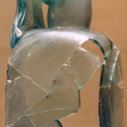 Woerden, Glass bottle |
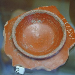
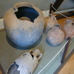 Woerden, Pottery |
Another interesting discovery is a dedication to the Syrian sun-god Elagabal from the mid-second century. The scarce remains of a monumental building in the village near the fort - a frescoed piece brick - were discovered in May 2003. The identification of this construction with a bathhouse is uncertain, but is additional evidence of the fifth, stone building phase of the fort. Another recent find that is worth noting is an asparagus knife.
Literature
- E. Blom, T. Hazenberg, W. Vos, "Het geroeide Nederlandse vrachtschip de ‘Woerden 7’. Onderzoeksresultaten van de opgraving van een Romeinse platbodem aan de Nieuwe Markt in Woerden (Hoochwoert)", Westerheem 55 (2006) 141-154.
- W. Vos e.a., Romeinen in Woerden. Het archeologische onderzoek naar de militaire bezetting en de scheepvaart van Laurium (2010)
- Wouter Vos et al., "De Romeinse limes tijdens Caligula: gedachten over de aanvang van het castellum Laurium en onderzoeksresultaten van de opgravingen uit 2002 aan het Kerkplein in Woerden" in Westerheem 52 (2003) 50-62.
- E.Blom en W.Vos, Woerden-Hoochwoert. De opgravingen 2002-2004 in het castellum Laurium, de vicus en van het schip de ‘Woerden 7’ (2008)
Wouter Vos kindly corrected this article.