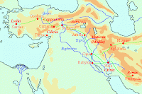
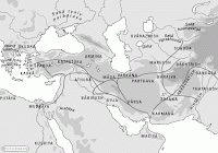
Herodotus describes the road between Sardes and Susa in the following words.note[Herodotus, Histories5.52-53.]
As regards this road the truth is as follows. Everywhere there are royal stations with excellent resting places, and the whole road runs through country which is inhabited and safe.
Through Lydia and Phrygia there extend twenty stages, amounting to 520 kilometers.
After Phrygia succeeds the river Halys, at which there is a gate which one must needs pass through in order to cross the river, and a strong guard-post is established there.
Then after crossing over into Cappadocia it is by this way twenty-eight stages, being 572 kilometers, to the borders of Cilicia.
On the borders of the Cilicians you will pass through two sets of gates and guard-posts: then after passing through these it is three stages, amounting to 85 kilometers, to journey through Cilicia.
Sardes, where the Royal Road started
The boundary of Cilicia and Armenia is a navigable river called Euphrates. In Armenia the number of stages with resting-places is fifteen, and 310 kilometers, and there is a guard-post on the way.
Then from Armenia, when one enters the land of Matiene, there are thirty-four stages, amounting to 753 kilometers. Through this land flow four navigable rivers, which cannot be crossed but by ferries, first the Tigris, then a second and third called both by the same name, Zabatus, though they are not the same river and do not flow from the same region (for the first-mentioned of them flows from the Armenian land and the other from that of the Matienians), and the fourth of the rivers is called Gyndes [...].
Passing thence into the Cissian land, there are eleven stages, 234 kilometers, to the river Choaspes, which is also a navigable stream; and upon this is built the city of Susa. The number of these stages amounts in all to one hundred and eleven.
This is the number of stages with resting-places, as one goes up from Sardes to Susa. If the royal road has been rightly measured [...] the number of kilometers from Sardes to the palace of Memnon is 2500. So if one travels 30 kilometers each day, some ninety days are spent on the journey.
The Halys
This road must be very old. If the Persians had built this road and had taken the shortest route, they would have chosen a different track: from Susa to Babylon, along the Euphrates to the capital of Cilicia, Tarsus, and from there to Lydia. This was not only shorter, but had the additional advantage of passing along the sea, where it was possible to trade goods. The route along the Tigris, however, lead through the heartland of the ancient Assyria. Important towns like Arbela and Opis were situated on the road. kingdom. It is likely, therefore, that the road was planned and organized by the Assyrian kings to connect their capital Nineveh with Susa.
It is certain that the Assyrians traded with Kaneš in modern Turkey in the first quarter of the second millennium BCE. The names of several trading centers and stations are known and suggest that the route from Assyria to the west was already well-organized. This road was still in existence in the Persian age.
The Persian Gate
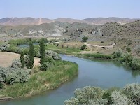
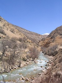
A traveler who went from Nineveh (which was destroyed by the Medes and Babylonians in 612) to the west, crossed the Tigris near a town that was known as Amida in the Roman age (and today as Diyarbakır). This was the capital of a country called Sophene. Further to the west, he crossed the Euphrates near Melitene, the capital of a small state with the same name, which may have been part of the Persian satrapy Cilicia. It is probable that the ruins of the guardhouse mentioned by Herodotus are to be found near Eski Malatya.
The border between Cilicia and Cappadocia was in the Antitaurus mountain range. The last town in Cilicia, and probably the place of the "two sets of gates and guard-posts" mentioned by Herodotus, was at Comana, a holy place that was dedicated to Ma-Enyo, a warrior goddess that the Greeks identified with Artemis.
The route continued across the central plains of modern Turkey, a country that was called Cappadocia. The exact course of the road is not known, but it is likely that it passed along the capital of the former Hittite Empire, Hattusa.
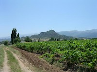
The Halys was crossed near modern Ankara (which may well have been a guard-post along the road) and the next stop was Gordium, the capital of another kingdom that had disappeared in the Persian age, Phrygia. The road has been excavated at this site and was 6 meters wide. Crossing the Phrygian plain and passing through Pessinus, a famous sanctuary dedicated to the goddess Cybele, and Docimium, famous for its pavonazetto marble, the Royal road reached Sardes.
At Persepolis, many tablets were found that refer to the system of horse changing on the Royal road; it was called pirradaziš. From these tablets, we know a lot about the continuation of the road from Susa through the formidable Persian gate to Persepolis (23 stages and a distance of 552 kilometers) and about other main roads in the Achaemenid empire. No less important was, for example, the road that connected Babylon and Ecbatana, which crossed the Royal road near Opis, and continued to the holy city of Zoroastrianism, Rhagae. This road continued to the far east and was later known as Silk road.
Herodotus describes the pirradaziš - for which he uses another name - in very laudatory words:
There is nothing mortal which accomplishes a journey with more speed than these messengers, so skillfully has this been invented by the Persians. For they say that according to the number of days of which the entire journey consists, so many horses and men are set at intervals, each man and horse appointed for a day's journey. Neither snow nor rain nor heat nor darkness of night prevents them from accomplishing the task proposed to them with the very utmost speed. The first one rides and delivers the message with which he is charged to the second, and the second to the third; and after that it goes through them handed from one to the other, as in the torch race among the Greeks, which they perform for Hephaestus. This kind of running of their horses the Persians call angareion.note[Herodotus, Histories8.98.]
Map of the main roads in the Achaemenid Empire
To the Greeks, this was most impressive. There is a story by Diodorus of Sicily that between Susa and Persepolis, even greater communication speeds were reached:
Although some of the Persians were distant a thirty days' journey, they all received the order on that very day, thanks to the skilful arrangement of the posts of the guard, a matter that it is not well to pass over in silence. Persia is cut by many narrow valleys and has many lookout posts that are high and close together, on which those of the inhabitants who had the loudest voices had been stationed. Since these posts were separated from each other by the distance at which a man's voice can be heard, those who received the order passed it on in the same way to the next, and then these in turn to others until the message had been delivered at the border of the satrapy.note[Diodorus, World history 19.17.5-6.]
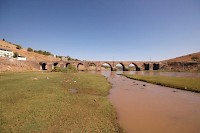
The bridge across the Tigris at Diyarbakir
We cannot establish whether this is true. If it is, it is the ultimate tribute to the Persian talent to organize this; if it is a mere fantasy, it is a beautiful compliment.
The road, although without the pirradaziš system, was still in use in Roman times. The bridge near Amida (modern Diyarbakir in eastern Turkey) is an illustration. In the fourth century CE, it was important enough to be defended by an entire Roman legion, V Parthica, and it remained important: the bridge was repaired several times.