Hannibal in the Alps
The Carthaginian general Hannibal (247-182 BCE) was one of the greatest military leaders in history. His most famous campaign took place during the Second Punic War (218-202), when he caught the Romans off guard by crossing the Alps.
Hannibal's route across the Alps is one of those historical questions that cause endless debate even though the subject has no importance whatsoever. This does not prevent us, however, from enjoying the puzzle and adding some extra speculations.
There are two ancient texts that give a description of Hannibal's route. The oldest is in the third book of the World History by the Greek historian Polybius of Megalopolis (ca.200-118 BCE). At first sight, this text seems to describe a rather northerly route, because it mentions a Celtic tribe, the Allobroges, which lived on the banks of the river Isère in the second century BCE. The other source is the twenty-first book of the History of Rome from its Foundation, written by Polybius' Roman colleague Titus Livius of Padua, better known to English readers as Livy (59 BCE-17 CE). He suggests a more southerly route. Both texts can be found here.
Livy and Polybius indirectly used the same eyewitness account. This may have been written by one of Hannibal's companions, Sosylus of Lacedaemon, who is known to have written a history of the Second Punic War in seven books. Polybius used the original text; Livy knew it indirectly. His real source cannot be identified, but we can be confident that this intermediary was a careful author, who meticulously copied all the chronological indications he found in the eyewitness report. He also added explanations; that these are correct cannot be known, but Livy's chronology is precise:
| Day 1 | March to the foothills; first encounters |
| Night | Camp on fairly level ground |
| Day 2 | Moves towards blocked pass |
| Night | Attack on abandoned blockade |
| Day 3 | Enemy attack on baggage train; capture of fortified enemy town |
| Night | Camp in enemy town |
| Day 4 | Easy march towards the main pass |
| Night | Not mentioned |
| Day 5 | Easy march towards the main pass |
| Night | Not mentioned |
| Day 6 | Easy march towards the main pass |
| Night | Not mentioned |
| Day 7 | Envoys from mountain tribe; their ambush |
| Night | Hannibal's infantry separated from cavalry and baggage train |
| Day 8 | Hannibal's army reunited; continued march towards the main pass |
| Night | Not mentioned |
| Day 9 | Hannibal's army reaches the main pass |
| Night | On the summit |
| Day 10 | Halt on the summit |
| Night | On the summit |
| Day 11 | Halt on the summit; it begins to snow |
| Night | On the summit |
| Day 12 | Precipitous, narrow, and slippery descent; landslide |
| Night | Camp on the ridge |
| Day 13 | Building a road |
| Night | Camp below the snow-line |
| Day 14 | Building a road for the elephants; infantry descends |
| Night | At least two camps below the snow-line |
| Day 15 | Building a road for the elephants; infantry descends |
| Night | At least two camps below the snow-line |
| Day 16 | Infantry reaches plain; first of three days' rest to recover from fatigue |
Although Livy's chronology is very detailed, there remain certain obscure aspects in his narrative. Polybius understands the military situation better. For example, he explains at the beginning of his story why the Celtic tribes had not attacked Hannibal before he started his crossing of the Alps.
So long as the Carthaginians had remained in the plains the various chieftains of the Allobroges had left them alone because of their fear both of the Carthaginian cavalry and also of the barbarian troops who were escorting them.
Explanations like these are absent from Livy's story. Besides, Polybius writes that
I have questioned men who were actually present on these occasions about the circumstances, have personally explored the country, and have crossed the Alps myself to obtain first-hand information and evidence.note
It is therefore tempting to regard Polybius as more reliable than Livy. He has first-hand knowledge of the Alps, has read the original eyewitness account, and understands army maneuvers. On the other hand, Livy has his qualities too, because he carefully copies what had been carefully copied. As a consequence, we cannot choose either of these historical texts as "most reliable".
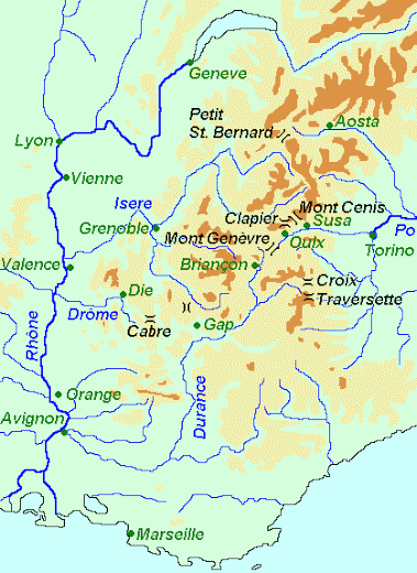
Another approach of the problem is to look at the passes in the Alps, and to find out which one suits the texts best. From north to south, these passes are:
- Col du Petit St Bernard
- from modern Bourg St Maurice and La Rosière to La Thuile and Aosta (N90 and SS26);
- advocated by Barthold Niebuhr, Theodor Mommsen, Lehmann, Viedebrandt, H. Kiepert and Francis de Conninck.
- Mont Cenis
- from modern Bramans and Val Cenis to Bar Cenisio and Susa (N6 and SP212);
- advocated by Napoleon Bonaparte, H. Nissen, D. Procter.
- Col du Clapier
- from modern Bramans and Le Planay to Grange Buttigliera and Susa;
- advocated by Perrin, P. Azan, Collins, Wilkinson, and Serge Lancel.
- Col du Montgenèvre
- from modern Briançon and Montgenèvre to Cesana Torinese and Oulx (N94 and SS24);
- advocated by Neumann, Fuchs, Gaetano de Sanctis and Peter Connolly.
- Col de la Croix
- from modern Abriès and l'Echalp to Pra Miraflores and Pinerolo.
- Col de la Traversette
- from modern Abriès and l'Echalp to Pian del re and Saluzzo;
- advocated by Sir Gavin de Beer, A. Guilleaume, and J. Prevas.
One of these passes has to suit the following pieces of information, on which Polybius and Livy agree:
- The pass has to offer sufficient room to build a camp for at least 20,000 soldiers, 6,000 cavalry and twenty-seven elephants (the number of men that would reach Italy);
- The defile should begin within 15 to 30 kilometers from the summit, because Hannibal's soldiers started to climb down on the day they left the camp on the summit;
- The road to Italy must be in a northerly direction: the soldiers encountered snows of the previous year when they were descending;
- The first part of the descent has to be narrow and steep;
- After this, the descent has to be less steep for about 50 kilometers, because it took Hannibal's men three days to reach the plain;
- Italy should be visible from the summit (according to Polybius) or from a point at the beginning of the precipitous descent (according to Livy), because Hannibal was able to show his men the plain during a speech.
Condition #6 is the least important, because Hannibal's speech was probably invented. This was a very common practice in ancient historiography: the reader expected short speeches in which the actors explained what they were doing and why. These explanatory speeches were usually included before a particularly important action took place. Since Polybius and Livy both liken the Alps to the walls of Rome, it is likely that the speech was already included in the original account. (Besides, the question seems inevitable how Hannibal's men could possibly see Italy if it were snowing, as Livy indicates.) As we can see in the table below, only one pass fits the sixth condition.
|
|
|
|
|
|
|
||
| Col du Petit Saint Bernard |
|
|
|
|
|
|
|
| Mont Cenis |
|
|
|
|
|
|
|
| Col du Clapier |
|
|
|
|
|
|
|
| Col du Montgenèvre |
|
|
|
|
|
|
|
| Col de la Croix |
|
|
|
|
|
|
|
| Col de la Traversette |
|
|
|
|
|
|
|
The only pass that fits all of the five main conditions is also the lowest, the Col du Montgenèvre between Briançon in France and Susa in Italy. There is an extra argument why this pass is the route taken by Hannibal: the distances best suit the distances mentioned by Polybius (252 kilometers from the Rhône to the beginning of the ascent, and from there to the plain of the Po 216 kilometers).
Now that we know that Hannibal crossed the Alps between Briançon and Susa, we can try to find the other stations of his march. The enemy town that was taken on the third day, can easily be identified with modern Gap, because it is a three days' march downstream from Briançon (i.e., days four, five and six). The fort captured by Hannibal's men must be the Mont Saint-Mens (ancient Vapincum), immediately south of the modern town.
It is harder to establish the route during the first days. Livy states that Hannibal started his march on the banks of a river called Druentia; this cannot be the Durance, because it is too southerly. The Drôme and Isère are possible, and the first one should be preferred because in that case the distance to Gap can be covered in two or three days. The pass which Hannibal took during the second night, can be identified with the Col de Cabre.note
Probably, Hannibal had always wanted to take the road to the Col du Mont Genèvre. It was a common road and the tribes along it knew the mores of international diplomacy (Polybius mentions how the tribe near the pass came to Hannibal with branches and wreaths, the usual symbols of submission.) However, the Carthaginians had already encountered a Roman army near the Rhône; making a detour along the Drôme and the Col de Cabre, and catching the main road again near Gap, was a diversionary tactic to give the Romans the impression that they had been able to divert him from the road to Italy.
| Day 1 | March along the Drôme from to the foothills; first encounters, near Die |
| Night | Camp on fairly level ground; near Die |
| Day 2 | March towards blocked Col de Cabre |
| Night | Attack on abandoned blockade at Col de Cabre |
| Day 3 | Enemy attack on baggage train; capture of a fort at Saint-Mens |
| Night | Camp in Gap |
| Day 4 | Easy march towards Durance and Col du Montgenèvre |
| Night | Camp near Prunières? |
| Day 5 | Easy march along the Durance towards Col du Montgenèvre |
| Night | Camp near Embrun? |
| Day 6 | Easy march along the Durance towards Col du Montgenèvre |
| Night | Camp near Mont Dauphin? |
| Day 7 | Envoys from tribe near Briançon; ambush 10 km before Briançon |
| Night | Hannibal's infantry separated from cavalry and baggage train |
| Day 8 | Hannibal's army united near Briançon; march towards Col du Mont Genèvre |
| Night | Camp at La Vachette, near the sources of the Durance? |
| Day 9 | Hannibal's army reaches the Col du Montgenèvre |
| Night | On the summit of Col du Montgenèvre |
| Day 10 | Halt on the summit of Col du Montgenèvre |
| Night | On the summit of Col du Montgenèvre |
| Day 11 | Halt on the summit of Col du Montgenèvre; it begins to snow |
| Night | On the summit of Col du Montgenèvre |
| Day 12 | Precipitous and dangerous descent for about 9 km (1854 to 1354 meters) |
| Night | Camp near Cesana Torinese |
| Day 13 | Repairing the road; infantry starts to descend |
| Night | Elephant camp near Cesana; infantry camp near Mollières |
| Day 14 | Building a road for the elephants; infantry descends |
| Night | Elephant camp near Cesana; infantry camp near Oulx |
| Day 15 | Building a road for the elephants; infantry descends to Susa |
| Night | Elephant camp near Cesana; infantry camp near Susa |
| Day 16 | Infantry stays at Susa; first of three days' rest to recover from the fatigue |
Literature
The arguments in this article were brought forward for the first time by Peter Connolly in his book Hannibal and the Enemies of Rome (1978 London). In the second edition of his Greece and Rome at War (2006), he mentioned later research that had confirmed his ideas.