Catabathmus
Q1245502Catabathmus (Greek Καταβαθμός, "descent"): cape and frontier town between Ptolemaic Egypt and Cyrenaica, modern Salum, also known as Hellfire Pass.
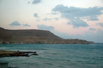
Catabathmus was the name of a large promontory, which was considered the frontier between Ptolemaic and Roman Egypt and Cyrenaica. The road along the coast is inaccessible, but there is an inland road, the Halfaya Pass, which is about 180 meters above the level of the nearby sea. The slope is mentioned by Polybius, Pomponius Mela, Pliny the Elder, and Orosius.note Going up and down is not very easy, making Catabathmus, "the descent", an important obstacle and a logical border. When Ptolemy VIII Physcon had to reconquer the Cyrenaica (162 BCE), he met resistance at this place.note
The Graeco-Roman geographer Strabo mentions it as the most western point of Egypt,note as the most eastern point of Cyrenaica,note and also knows that the area was destitute of water.note The site was fortified and called Tetrapyrgia, "four towers", while its harbor was called Plynus.note Several other ancient authors mention the town: the Roman author Sallust knows that it is along the coastal road, while the Alexandrian scientist Ptolemy offers coordinates.note
Today, the town is known as Sallum or Sollum; in the Second World War, the Halfaya Pass became notorious as the Hellfire Pass.