Constantinople has had several walls. The oldest of these surrounded the Akropolis and was built by the first Greek settlers. According to the author Dionysius of Byzantium (second century CE), the walls were thirty-five stades long, or about six kilometers, and the sector that was facing the land was about five stades wide, less than a kilometer. There were twenty-seven towers, which served as catapult emplacements. Later, the Roman emperor Septimius Severus rebuilt the city (in 203, and the new, Roman walls were about 300 m to the west of the Greek walls. A part of the Severan Sea Wall is still visible in the northeast of modern İstanbul.
After 324, Constantine the Great expanded the city to the west. The new walls, which surrounded an area of 6 km² and were about two km west of the Severan walls, were probably finished when the city was dedicated as the Empire's new capital. They had been built by 40,000 POWs of Constantine's campaigns against the Goths.
The city continued to grow. During the reign of Theodosius the Great (378-395), the suburb known as Kainopolis stretched forward along the Via Egnatia for almost 2½ km outside the walls of Constantine. The triumphal arch that was known as Golden Gate now marked the true beginning of the urban area.
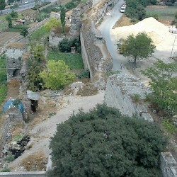
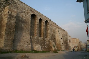
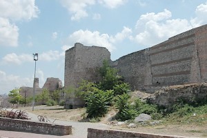
It was the capture of Rome by the Visigoths in 410 that forced the Byzantine government to build a fourth wall, which is called the Theodosian Wall, and is about 1½ km wall of the wall of Constantine. It must be admitted that the emperor Theodosius II (408-450) can take little personal credit for its construction: the man who was responsible, was his praetorian prefect, the capable Anthemius, who was the effective ruler of the eastern part of the Roman world when Theodosius was still a boy. The wall was built in 412-414, surrounded an area of 12 km², was 12 m high, and had 96 towers that were about 18 m tall. Two related projects were the construction of the Aetius Cistern, close to the new walls, and improved Sea Walls (439).
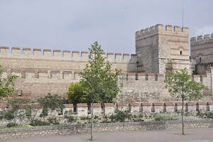
Section of the walls of Constantinople: Anthemius' wall, Cyrus' wall, battlements, and moat.
In 447, the walls were partly destroyed by an earthquake, which was all the more worrying because the Huns were by now making aggressive raids. Theodosius ordered the praetorian prefect, Cyrus of Panopolis, to rebuild and strengthen the fortifications. A second wall, about 8 m high, was built in front of the original wall, and the number of towers was doubled, so that there were now 192 of them. Two inscriptions near the Rhegium Gate (now called Mevlevihane) claim that the job could done in sixty days because the fans of the famous Circus factions were doing the work. The third, low, wall and the moat were created later. A final addition was the wall around the Blachernae Palace, hastily built before when the Avars besieged Constantinople in 627.
Constantinople, Theodosian Wall, south of Charisius Gate
Constantinople, Theodosian Wall, Charisius Gate
Constantinople, Theodosian Wall, Southern section
Constantinople, Theodosian Wall, north of Golden Gate
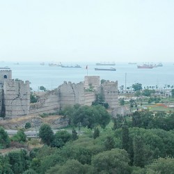
The Theodosian Wall is almost 5½ km long. It begins on the shores of the Golden Horn, near the Blachernae Palace, and continues to the south, to the Golden Gate - which was included in the new wall - and Sea of Marmara. There are many gates. From north to south:
The Circus Gate, after a wooden amphitheater in this neighborhood ;
The Gate of Charisius;
The Fifth Military Gate;
The Gate of Saint Romanus;
The Fourth Military Gate;
The Gate of the Rhegium;
The Third Military Gate;
The Selymbria Gate or Gate of the Spring, named after a source that was venerated by the pagans and had been converted into a Christian sanctuary, the Live Giving Spring (Zoodochus Pege);
The First Military Gate, also known as the Gate of Christ, named after a christogram on top of it.
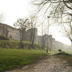
Wall near the Blachaenae Palace
These defenses could not be captured by any medieval attacker, and withstood several sieges by - among others - the Avars, the Arabs, and the Bulgarians. However, after the Crusades, the Empire was exhausted and the city was no longer as populous as it once had been. When the Ottoman sultan acquired cannon, the walls of Constantinople were rendered obsolete. On 29 May 1453, the Gate of Saint Romanus was destroyed by artillery, the garrison of the Circus Gate was seized, and the Fifth Military Gate was stormed by the Turks. The city was finally captured. It was the end of the Byzantine Empire, which had, for more than eight centuries been Christianity's bulwark against the armies of Islam.
In his book Byzantium. The Early Centuries (1988), historian Julius Norwich, summarizes the importance of the walls:
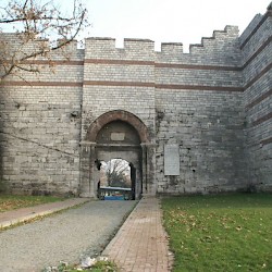
Wall north of the Charisius Gate
It is one of the clichés of Constantinople that it should, ideally, be approached from the sea. Only then, we are told, can the uniqueness of its geographical position be properly appreciated, to say nothing of that famous skyline of dome and minaret which has symbolized, for as long as any of us can remember, the Mysterious East. With this opinion we cannot easily disagree; but for those us on whom Byzantium will always cast a more powerful spell than Islam, there is another approach every bit as satisfying and very nearly as spectacular. No one, surely, whose first arrival has been by road from Edirne, can ever forget that first astonishing sight of the Land Walls, looming up from the surrounding plain, their huge russet-striped towers splintered and occasionally shattered, magnificent witnesses to bludgeonings - by attacking armies and, more recently, by Turkish traffic - that they have endured for nearly sixteen centuries. Running just over four miles from the Marmara to the upper reaches of the Golden Horn - and thus enclosing a far greater area than those earlier fortifications traced by Constantine - they totally close off the city by land; only once, after more than a thousand years, were they ever breached - a breach that was to spell the end of the Byzantine Empire.note[Julius Norwich, Byzantium. The Early Centuries (1988), p.139.]