Herodotus on the First Circumnavigation of Africa
The Greek researcher and storyteller Herodotus of Halicarnassus (fifth century BCE) was the world's first historian. In The Histories, he describes the expansion of the Achaemenid empire under its kings Cyrus the Great, Cambyses and Darius I the Great, culminating in king Xerxes' expedition in 480 BCE against the Greeks, which met with disaster in the naval engagement at Salamis and the battles at Plataea and Mycale. Herodotus' remarkable book also contains excellent ethnographic descriptions of the peoples that the Persians have conquered, fairy tales, gossip, legends, and a very humanitarian morale. (A summary with some historical comments can be found here.)
Context
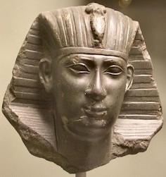
The Egyptian king Necho II, or - more properly - Wehimbre Nekao, was the ruler of the kingdom along the Nile from 610 to 595 BCE. When he started his reign, there were serious military problems on Egypt's northeastern border. The Babylonians had taken the Assyrian capital Nineveh (text) and were ready to punish Egypt for its support to the Assyrian cause.note From a Babylonian text, the Nebuchadnezzar Chronicle, we know that Necho was campaigning in Syria from 609 until 605, when the Babylonian king Nebuchadnezzar decisively defeated the Egyptians at Karchemiš (in Syria).
The Babylonian proceeded to subjugate the towns along the Mediterranean coast. It is not entirely clear where and when the border between Egypt and Babylonia was drawn: 2 Kings 24.7 implies that Egypt retired to the Sinai desert and left the Palestine coast in Babylonian hands; Herodotus 2.159 suggests that Gaza remained an Egyptian stronghold.
However this may be, it is obvious that the pharaoh was in big troubles for some time, and he seems to have considered the possibility to attack southern Babylonia by sea. He ordered a canal to be constructed between the Nile and the Red Sea, but discovered that he was giving free access to his enemies too. Consequently, the canal remained uncompleted until the Persians had taken over Egypt in the last quarter of the sixth century.
The circumnavigation of Africa must somehow have been related to Necho's defense projects. He asked for Phoenician assistance because the Phoenicians (who lived in modern Lebanon) were excellent sailors and had several colonies in the West, such as Carthage and the islet of Mogador opposite modern Essaouira. The Phoenicians must have been happy to help the Egyptians, because they shared the Babylonian enemy. Here is Herodotus' account of the vovage, in a translation by Aubrey de Sélincourt.
Herodotus' story
Libya is washed on all sides by the sea except where it joins Asia, as was first demonstrated, so far as our knowledge goes, by the Egyptian king Necho, who, after calling off the construction of the canal between the Nile and the Arabian Gulf, sent out a fleet manned by a Phoenician crew with orders to sail west about and return to Egypt and the Mediterranean by way of the Straits of Gibraltar. The Phoenicians sailed from the Arabian Gulf into the southern ocean, and every autumn put in at some convenient spot on the Libyan coast, sowed a patch of ground, and waited for next year's harvest. Then, having got in their grain, they put to sea again, and after two full years rounded the Pillars of Heracles in the course of the third, and returned to Egypt. These men made a statement which I do not myself believe, though others may, to the effect that as they sailed on a westerly course round the southern end of Libya, they had the sun on their right - to northward of them. This is how Libya was first discovered by sea.note
Reconstruction of the voyage
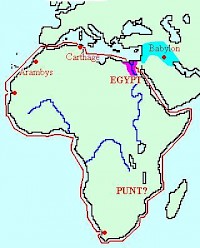
The following is a possible reconstruction of their voyage. They must have started their expedition in July, and they must have reached the Horn of Africa after an uneventful trip, relying on the northern wind. The Red Sea (which Herodotus calls "Arabian Gulf") was well known to their Egyptian pilots, because the Egyptians traded incense with the Arabs of modern Yemen.
The Egyptian sources inform us also about the legendary country named Pwanit or Punt, which is probably identical to Eretria and eastern Ethiopia (more...). The first part of the expedition of the Phoenicians covered known territories.
After they had passed Africa's most eastern shores, the northeast monsoon - which started in October - sped up their journey, and in March they must have reached the equator. The Agulhas Current must have brought them through the Mozambique Channel and along the coast of modern South Africa. Sailing on their westerly course, they must have observed that they had the sun on their right. (Something that Herodotus, who was unaware of the earth's spherical shape, was unable to believe.) Something else must have fascinated these men, too: they must have seen whales.
When they reached Cape Agulhas, they left the current that had helped them to the south. At the same time, they encountered the contrary South East trade winds. And they must have been surprised to discover that here, on the southern hemisphere, the winter was already approaching. However, they must happily have noticed that they had started to go north. The plain behind Saint Helena Bay, 150 kilometers north of modern Cape town, offered a fine opportunity to land. They must have sowed their wheat in June, started to repair their ships, and harvested in November.
The Benguela Current and the now favorable South East trade winds brought the Phoenician sailors back to the hot equatorial regions, and they will have experienced its effects in a most unpleasant way, when they sailed along the Namibian coast, which is a waterless desert. It took several weeks to reach a more fertile coast. In March, a new and equally unpleasant surprise awaited them: they had been traveling on a northerly course, but now, the coast curved to the west again. They may have benefited from the westward Guinea Current, but not for long, because it changes its direction during the spring. For weeks, they were struggling against the wind and the current, only to reach -in July- the African west coast, where they encountered the contrary Canary Current and the North Eastern trade winds. But they must have been relieved to find themselves rowing in a northerly direction again.
Somehow they managed to beat against the wind and the current, and in November they must have landed somewhere on the coast of modern Mauritania, maybe at Bay of Arguin, where their Carthaginian compatriots were to build the trading post of Kerne in the not too distant future. The voyagers sowed their wheat, repaired their ships, and waited for the next harvest. Maybe they made contact with the Berber population; in that case, they may have learned that they could obtain gold from the Bambouk region if they returned to the mouth of the Senegal - something that the Carthaginian sailor Hanno probably did.
In May, they brought their ships to the sea, and started to beat their way up to along the Moroccan coast, where they discovered that they had returned to the world they knew: the town on Mogador island was occupied by Phoenicians. Having told the incredible story of their trip to the southern hemisphere, and no doubt with new equipment, they continued their voyage; soon they reached Phoenician towns like Lixus, modern Cadiz and Malaga, and Carthage. They must have reached Egypt at the end of the summer. Their expedition had lasted three full years.
This story, told by Herodotus, was generally questioned after the famous geographer Ptolemy had said that it was impossible to circumnavigate Africa. Another voyage was necessary to vindicate the Phoenician claims. This trip was made in 1488, when Bartolomeus Diaz reached the Cape of Good Hope.