Ceuclum (Cuijk)
Q3414036Ceuclum: Roman village in Germania Inferior, along the river Meuse, modern Cuijk in the Netherlands.
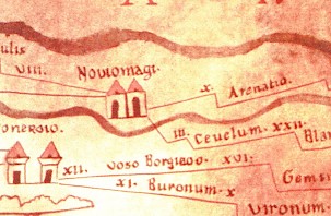
The Peutinger map, a medieval copy of an ancient Roman road, is one of the most important documents for reconstructing the ancient settlement pattern in the Dutch river area. This is not surprising, because there is no natural stone in the Netherlands and the large rivers change their course every now and then. Impressive ruins are rare, and we are left with this map if we want to understand the outlines of the settlement pattern.
The picture shows a detail of this map. In the center is Noviomagus (modern Nijmegen), situated between the rivers Rhine and Meuse. When we cross the Meuse to the south, we find, at a distance of three leagues or 6.6 kilometers, Ceuclum. The identification of Ceuclum with modern Cuijk dates back to the Renaissance and is secure. (The fact that the distance between Nijmegen and Cuijk is in fact some 15 kilometers is not really worrying, because Cuijk is correctly depicted south of the Meuse. There is probably a scribal error: III instead of VI.)
An indication of the first inhabitants is the name: Ceuclum is probably derived from a word like keukja, Celtic for "curved river". It is not certain whether the native population spoke Celtic, but if they did not, they spoke a language that was related to it, although more archaic.
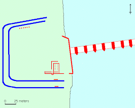
Excavations have shown that from the reign of the emperor Claudius (41-54) on, there was a small wooden fort at this site, perhaps built by the governor of Germania Inferior, Cn. Domitius Corbulo, who was interested in the traffic between the Meuse and Rhine. Ceuclum was (and is) situated on a small hill, an ancient river dune. Archaeologists have been able to trace the two (or three?) ditches of this first fort, which measured some 150x120 meters and must have offered accommodation to some 500 soldiers. Fort Ceuclum may have monitored the Batavians in the north and west.
There is no real evidence for its destruction during the Batavian revolt (although there are traces of a burning layer), which suggests that it was evacuated when the news of the rebellion arrived. After 70, the garrison seems to have moved to another place. There is a conspicuous absence of coins from the age of the emperor Domitian (81-96). Possibly, the transfer was connected to the removal of the Tenth legion Gemina, which had been stationed near Nijmegen and was sent to Budapest at the same time. A great treasure of silver coins dating to the early 220s is exceptional because it was buried at a place that had been struck by lightning.
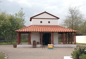
Usually, there was a village or vicus near a military camp, where inn-keepers and merchants lived, and where soldiers could visit their girlfriends. In the second century, the villagers constructed on the site of the former fort a building that has been interpreted as a sanctuary; it measured 17½ x 16½ meters. A smaller temple was found in the neighborhood. Another building in the vicus that has been identified is the bathhouse.
It has been assumed that the garrison had not really left Ceuclum, but occupied another fort, situated three kilometers to the north. Unfortunately, the only argument for this idea is a single military stamp on a roof-tile. The new village measured some 6-10 hectares, which suggests that there were some 500-750 people living at Ceuclum.
In the third century, a cultural change occurred among the Germanic tribes north and east of the Rhine. They became better organized and more aggressive; the names of the old ethnic groups disappear and we hear of hitherto unknown tribes, such as the Franks and the Alamanni. In 260, the Franks invaded the Roman empire, but they were defeated somewhere in Noord-Brabant (the south of the Netherlands) by a general named Postumus, who was immediately proclaimed emperor. He was the founder of an independent Gallic Empire, which successfully defended the Rhine frontier.
To do this, a new type of defense was developed. The Romans had always guarded the Rhine frontier, but there had never been a strategic reserve behind this first and only line of defense. The emperor Septimius Severus had started an experiment with one legion (II Parthica) that stayed in Italy and could be sent to any crisis situation. The emperors of the Gallic empire improved upon this idea. They retained a first line, which any enemy would have to cross, and placed a strong cavalry army in the hinterland. Invading Franks or Alamanni were now faced with a difficult choice: if they invaded the Gallic empire and besieged the strongholds near the river, they lost time and the Roman cavalry would arrive; but if they ignored the forts along the river, they could be attacked in the rear.
However, in the summer of 274, the Gallic emperor Tetricus was defeated by the emperor of the "real" Roman empire, Aurelian. This was a catastrophe. Although the Roman empire was reunited, many troops were transferred from the Rhine to other frontier zones. Immediately, the Franks invaded again, and this time, there was no large garrison left to drive them back. The Dutch river area was lost to the Germanic tribes. Cuijk suffered heavily: the two cemeteries (to the south and northwest of the village) were not used after 275.
Almost twenty years later, the Roman emperor Constantius I Chlorus (293-306) restored order. (It was imperative to reconquer the Dutch river area, because British grain was necessary to feed large cities like Cologne, and grain could only be transported by boat.) Constantius reorganized the frontier according to the principles of the old Gallic empire. During the reign of his son Constantine the Great, (306-337), frontier towns like Nijmegen were heavily fortified, and towns in the hinterland like Tongeren became cavalry bases.
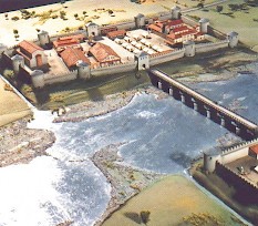
The roads between these towns had to be improved too. River crossings, which had always been time-consuming, were improved by building bridges, and the bridgeheads were fortified. Within this framework, we have to understand the renewed fortification of Cuijk during the reign of Constantine.
The new fort at Cuijk was situated at the same site as the first one, and was almost the same size. It was surrounded by an earth and timber rampart. Inside was a large granary. A structure that can perhaps be interpreted as a quay can dendrochronologically be dated to 320-342, i.e. to the second half of the reign of Constantine I the Great or the first half of the reign of his son and successor Constans (337-350).
Perhaps the quay - if this structure was a quay - was necessary for the construction of the bridge, which can dendrochronologically be dated between 347 and 349.
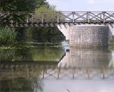
The location for the bridge was chosen because, to the best of the Romans' knowledge, the Meuse had never meandered at Ceuclum; nor has it since, for geological reasons only elucidated in the 1990s. It was a large project. Assuming that the bridge had a length of 150 meters, 1600 m³ of wood, nine tons of metal, and 5,000 tons of stone were needed - which would have required a train of 120 wagons. The bridge seems to have been similar to the one at Palzem in Luxembourg.
The bridge at Cuijk was a vital link between the first-line forts and the cavalry bases in the hinterland. The road from the south forked at the other side of the bridge: one road lead to the fort at Nijmegen, the other to forts along the Rhine at Qualburg (Quadriburgium) and Altkalkar (Burginatium) in the east. Along these roads, watchtowers were erected, so that the garrisons of the forts along the Rhine could give signals to warn the cavalry in the south. One of these military installations has been discovered near Heumensoord, halfway between Nijmegen and Cuijk.
The bridge piers were placed at a distance of 19 meters and measured 17x7 meters (these dimensions are comparable to the size of the piers of the Roman bridge across the Rhine at Mainz). Since the river channel in Roman times cannot have been wider than 150 meters, there must have been at least eight piers to carry the bridge. It is also possible that the entire valley was bridged; in that case, its length must have been almost half a kilometers (and that wagon train would have numbered 360 wagons). It is interesting to note that the piers were made of natural stone, which had to be imported from the upper valley of the Meuse. As most Roman bridges in Northern Europe, it had a wooden span.
When the construction of the bridge started, a peculiar building sacrifice was made: a silver coin. It was put into a clamp-hole for an iron clamp that joined two building stones, before the clamp was fixed by pooring molten lead into the hole. However, it was not just any coin, it was a coin that was almost five hundred years old: a denarius from 135 BCE.
After the death of Constans, the empire was ruled by his brother Constantius II, who was not really interested in the west. The reign of an usurper named Magnentius made the situation even more complex. In 355, the Franks were able to break through and settled in Brabant and Limburg (which is why the Dutch and Flemings speak a Germanic language). The Roman general Julian accepted them as new citizens. In these years, the bridge at Cuijk fell into disrepair.
A second building phase can be dated to the winter of 368/369. In the preceding summer, the emperor Valentinian I (364-375) had been fighting against the Germanic tribes, and in September, he had visited Nijmegen. He must have seen that several fortifications needed repair. The fort was reconstructed out of stone, a double ditch was dug, and heavy semicircular towers were added.
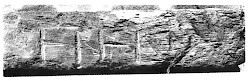
The bridge was repaired as well. Perhaps the engineers silently complained about the mess that had been made during the preceding decade, because on one of the piles a short text was inscribed, eterna. This is the late antique spelling of the word aeterna and it may or may not suggest that the engineers thought that their bridge did not have construction errors but was made for eternity.
Unfortunately, they were wrong. The bridge needed to be repaired again in 393. (Roman bridges had to be repaired roughly every generation.) It proves that Roman control of the area was still intact in c.400. However, it was not to last. In 406, troops were transferred from the Rhine frontier to Italy, and in the first days of 407, Germanic tribes crossed the river. Roman control of the Rhine area was never restored, and the new, Frankish authorities never rebuilt the bridge, which must have collapsed at some time in the first half of the fifth century. The village, itself, however, remained occupied.
Literature
- T. Bechert and W. Willems, Die römische Reichsgrenze zwischen Mosel und Nordseeküste (1995 Stuttgart)
- J.E. Bogaers, "Opgravingen te Cuijk 1964-1966" in: Nieuws-Bulletin van de Koninklijke Nederlandse Oudheidkundige Bond 65 (1966) 65-72.
- H. van Enckevort & J. Thijssen (eds.), Cuijk. Een regionaal centrum in de Romeinse tijd (2002 Utrecht)
- B. Goudswaard, R. Kroes, H. van der Beek, "The Late Roman Bridge at Cuijk", in: Berichten van de Rijksdienst voor het Oudheidkundig Bodemonderzoek 44 (2000) 440-560
- R.A.C. Kroes et al., "Geomorphology and the Reconstruction of a Late Roman Bridge in Cuijk", in: Proceedings of the Second Conference on Alluvial Geoarchaeology 2000 (2003 Leeds)