Rhenus (Rhine)
Q584Rhine (Latin Rhenus): the largest river in northwestern Europe. As the frontier of the Roman empire and (with the Rhône) main transport corridor between the Mediterranean and the North Sea, it played an important role in shaping the history of the old world.
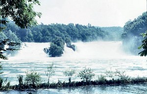
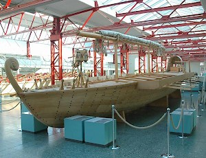
With a length of 1326 kilometer, the Rhine is one of the longest rivers in Europe. Its sources are in the Swiss Alps, in an area that is connected by the Splügen Pass with Lake Como and Italy. The two mountain streams unite at Reichenau near Chur (ancient Curia). From this confluence, the river flows to the Bodensee, a big lake, 150 kilometers to the north and almost two kilometers lower. From this lake, once known as Lacus Brigantinus, the river turns to the west and thunders over the splendid Schaffhausen cataract. Every second, more than 600 m³ falls down twenty-three meters. At Windisch (Vindonissa), the Rhine is joined by the river Aare (Arurius), and becomes navigable.
After reaching Augst (Colonia Augusta Rauracorum) and Basel, it takes a generally northern course between the Vogeses and the city of Strasbourg (Argentoratum) in the west, and the Black Forest in the east.
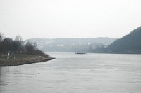
In Basel, the river's capacity is more than 1040 m³ per second, and this rapidly increases. Among the first contribuaries is the Neckar (Nicer). Near Mainz (Mogontiacum), the river is joined by the Main (Moenus). There was a bridge. After Mainz, the Rhine breaks through the Taunus mountains, and the next big city, Koblenz (Confluentes), is called after the confluence with the Moselle (Mosella), which is the corridor to the Saône, Rhône, and Mediterranean Sea.
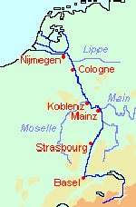
Until Koblenz, the Rhine was streaming through the Roman province of Germania Superior, which had once been a Celtic-speaking country. (In fact, the word "Rhine" or Rên is Celtic and means "stream".) At the Vinxtbach near Remagen (Rigomagus), the river enters Germania Inferior and reaches the northern plains, where new, eastern rivers contribute to the width of the stream: the Sieg, Wupper, Ruhr, and the lovely Lippe (Lipua).
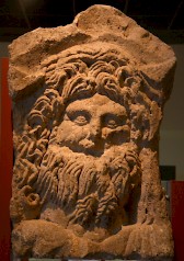
On the west bank, people had once been speaking Germanic languages, and on the east bank, they still did, because the Rhine became in the first century CE the frontier (limes) between the Roman empire and "free" Germania. At regular intervals, there were forts for the auxiliary troops, and on some places the legions had their fortresses. Their commander resided in Cologne (Colonia Claudia Ara Agrippinensium).
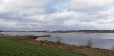
After the Lippe and the Roman city of Xanten (Colonia Ulpia Vetera), the mighty Rhine, which at this point has a capacity of 2100 m³, turns to the west, and divides into two branches: the large Waal (1540 m³) passes along Nijmegen (Noviomagus) and goes straight to the west, whereas the comparatively small Lower Rhine (660 m³) continues to the northwest. (The land between these branches was, in Antiquity, called "the island of the Batavians" and is now called Betuwe.) The two branches were well known: the Roman poet Virgil calls the Rhine bicornis, "with two horns".note
After the bifurcation, the Rhine slows down. If the water is high in Mainz, it takes three days to reach the point where the river divides into Waal and Lower Rhine. From here to the sea is another three days, although it is less than half the distance to Mainz.
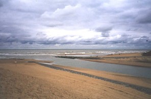
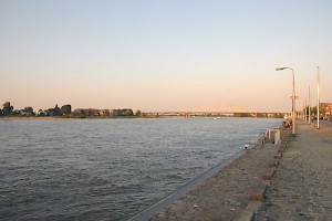
In Antiquity, the Lower Rhine was larger than today. In the second decade BCE, the Roman commander Drusus built a dam (moles Drusiana, near modern Herwen) that pushed more water to the Waal; and he ordered the digging of a canal, the Fossa Drusiana, to connect the river to Lake Flevo. Other branches of the Lower Rhine are the Lek (to the west) and the Vecht (to the north). When the Rhine ultimately reaches the North Sea near Katwijk (ancient Lugdunum), it is not a very big river anymore.
The Greeks and Romans hardly knew about the existence of this river until Julius Caesar reached it in 58 BCE and declared that it was the boundary between the Gallic (or Celtic) nations in the west and the Germanic tribes in the east. This is simply untrue: along the Upper Rhine, the Celtic culture continued along the Danube to Bohemia, and further to the north, the Germanic language had already advanced west of the Rhine into what is now Belgium. Yet, Caesar needed a clear demarcation of the war zone, and this is why people still think that the Rhine divided two races.
To the Romans, the Germanic tribes were awe-inspiring, and the senators must have been shaken with excitement when Caesar crossed the Rhine in 55 and 53 BCE (more...). His expeditions had no military results whatsoever, but they impressed his contemporaries.
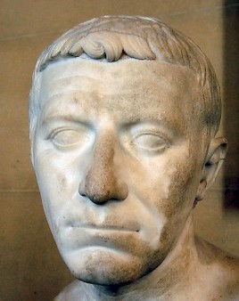
Later generals also crossed the river. Marcus Vipsanius Agrippa attacked the inhabitants of the east bank and seems to have resettled people from the Taunus area in the Rhine delta: the Batavians. The Ubians received a similar treatment and were the first inhabitants of Cologne. Later, prince Drusus conquered the Lippe area, where towns like Haltern and Anreppen were founded. However, after the Roman commander Quinctilius Varus had been defeated in the Teutoburg Forest, in 9 CE, the Romans gave up their attempt to conquer the east.
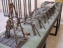
The Rhine started to become a real frontier when Drusus' grandson, the emperor Caligula, visited the Rhineland in 40, and ordered the construction of fortifications in Germania Inferior. In 41, he was succeeded by Claudius, who appears to have ordered more constructions, and made the strategic decision to make this frontier permanent. When general Domitius Corbulo in 47 crossed the river, he was recalled. Corbulo who is also responsible for the Canal of Corbulo (Fossa Corbulonis), which still connects the two branches of the Rhine. After this, the Lower Rhine remained the fixed northern frontier of the Roman empire until the early fifth century, although it was sometimes threatened (e.g., during the Batavian revolt in 69-70).
After 70, during the reign of Vespasian, the Romans started to occupy the east bank of the Middle Rhine south of Mainz. Soldiers of the Eight legion Augusta built a road from Strasbourg through the valley of the Upper Neckar to the sources of the Danube. This was the beginning of the occupation of the Black Forest (often called Agri decumates). It is almost certain that the same legion was part of the forces that the emperor Domitian employed (in 83/85 and 88/89) against the Chatti, who threatened the newly conquered Roman possessions on the east bank of the Rhine. He built a large palisade through the Taunus, to protect the conquered area; later, Hadrian expanded this palisade to the Neckar area; and still later, Antoninus Pius and Caracalla improved these fortifications.
In 260, the Agri decumates were lost to a new tribal federation, the Alamanni. Yet, the Rhine frontier itself remained intact and was to last for another century and a half, although the original wooden fortresses and forts on the west bank were gradually replaced by stronger buildings of natural stone. On the east bank, there were impressive castles that guarded the bridgeheads; an example is the immense bulwark at Divitia (Köln-Deutz), which protected the bridge at Cologne against another federation of Germanic tribes, the Franks. It was only in the first decade of the fifth century that the Rhine frontier was given up.
The fact that the Rhine was a boundary had important consequences, because there were thousands of soldiers who needed food. As an indication: in the second century, we find four legions of 5,300 men each along the Rhine: XXX Ulpia Victrix at Xanten, I Minervia at Bonn, XXII Primigenia at Mainz, and VIII Augusta at Strasburg. There were as many auxiliary soldiers - taken together, more than 40,000 soldiers. (At the end of the reign of Augustus, the Roman forces had been twice as strong.) These men needed more grain than the Rhineland could produce, and when the annexation of the valley of the Lippe failed, it had to be imported from the area of the Meuse and Moselle. The demand for food was an enormous economic incentive.
At the same time, the soldiers spent their money in the towns along the river, which rapidly became important cities and started to import all kinds of other products. In return, the cities produced metal, pelts, and hair (for wigs and catapults), and traded amber, horses, slaves, and silver. The Rhineland, which was connected with the Mediterranean by the Moselle, Saône, and Rhône, urbanized and became an important economic zone. Although the area was taken over by Franks and Alamanni in the early fifth century, the urban infrastructure more or less survived. In the Middle Ages, the corridor of Rhône, Saône, Moselle, and Rhine was again the economic axis of Europe.